


"A Canny Walk Home" (Part 2: My Route)
A Backpacking Adventure from Nottingham to Newcastle

To read Part 1, click here
My Route
As well as people asking me, with a puzzled expression (⊙.☉), if I was going to walk home up the A1 motorway (see Part 1), they also suggested, “Why not take the Pennine Way?” And this was my first inclination.
For any British backpacker, ‘The Pennine Way’ is an alluring prospect. Britain’s oldest national trail opened in 1965, and we all know someone who has completed it. My father told me an amusing story about a friend (let’s call him ‘Bob’) whose parents walked it when he was a child. But because they lived in Nottingham and had limited time, they completed it in short sections as day walks, parking one car at either end and meeting for lunch in the middle. So, on a twelve-hour day of driving and walking, they would only see each other for 20 or 30 minutes, which, I guess, must have suited them. Bob would start with one parent, and when they met in the middle, he was allowed to choose to continue with the same parent, or swap, and walk back the way he had come with the other. So, he never completed the whole thing and can’t remember which sections he’s missing!
If I wanted to incorporate The Pennine Way into my journey, I would need to head north-west from Nottingham to Edale in Derbyshire, before walking about three-quarters of the trail up the spine of England to Northumberland before veering east to Newcastle. I seriously considered this, bought the Cicerone guidebook and read it from cover to cover. But… the descriptions left me cold (apologies to those who love it).

Although I’ve walked extensively in the North Pennines – and highlights included intricate limestone pavements of the Yorkshire Dales, the dramatic High Cup Nick escarpment near Cross Fell, and mist rolling around the radar station on Great Dun Fell like the backdrop to a Sci-Fi movie – I was concerned the route might become monotonous, especially if walking in cloud, which in my experience, is often the case. And, for me, peat bogs and nature-starved grouse moors are best savoured in small quantities.
So, I poured over my maps and devised an alternative, which, for most of its length, skirted east of the A1. Although this route was less hilly, it had some big hitters for me regarding landscape and nature: ancient woodland, wetland, canals, patches of lowland heath, bucolic villages, ruined castles, and eventually the North Yorkshire Moors. The scenery would be ever-changing, and I’d learn more about the places I’d overlooked on those many long car journeys between my two hometowns.

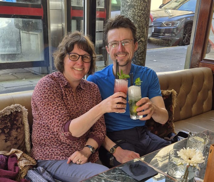
Finally, it was settled. From Nottingham, I would trek north through Sherwood Forest before joining the Chesterfield Canal that crosses under the A1 in north Nottinghamshire. I would then stay east of the A1 all the way to Newcastle: traverse the flat lands of North East Lincolnshire to Goole (at 80 miles); follow the River Ouse and a disused railway line to York (at 110 miles); cross the Howardian Hills and North Yorkshire Moors to Stockton-on-Tees (at 180 miles); and finally follow another disused railway line through the old pit villages of County Durham to the Penshaw Monument (at 210 miles). From there, it would be a hop, skip and a jump across the rivers Wear and Tyne to the finishing line at Gray’s Monument in the centre of Newcastle, where, if all went well, Tracy would help celebrate my arrival with cocktails, at the Gray Owl. A total of thirteen days not on the road.
I lavished care and attention on every stage of my route, customising it to avoid long stretches of road and maze-like field systems with gates, styles and cows. I sought out long-distance footpaths that took me in the right direction (such as a stunning section of the Cleveland Way) and bridal paths, canal towpaths, and disused railway lines.
At first, I planned to skirt around York to the east, but subsequently embraced it as a fulcrum of my journey, where I enjoyed a day off visiting my godson, Nathaniel. In York, we did a tour of the mind-blowing medieval walls (something I’d spectacularly failed to do on my not-infrequent work trips to York over the last 25 years) and randomly tagged along with an upbeat American couple called Nancy and Jay from Colorado, adding an unofficial extra 2 miles to my total distance.
As I walked, I had plenty of time to come up with names for this new route from Nottingham to Newcastle. I think the three best were: ‘THE KING’S WAY’, ‘THE MINER’S WAY’, and ‘NOT THE PENNINE WAY!’. I’ll let you be the judge.
View my route here as GPX files:
Section 1 (Nottingham to Goole, 84 miles): here
Section 2 (Goole to Stockton, 92 miles): here
Section 3 (Stockton to Newcastle, 44 miles): here
CONTINUE READING: PART 3
Yes Marek! Following your trip